URBAN DESIGN – BAES 4136
Introduction to Urban Design Theories
There could be several reasons why a student of Architecture needs to study Urban Design. One main reason that I could think of is the explosive growth of the urban population. Another is the influence of many policies being imposed from the time the city started until now. The changes in morphological aspects could be studied by many theories of urban form. Another reason is the profession of an “Urban Designer” needs to be addressed. There is a grey area between Planning and Urban Design. The Urban Designer is becoming more important due to architecture or shall we say ‘buildings’ becoming more isolated with all the regulations imposed by city planners and designers treating the external space as “left-over spaces”.
I would like to illustrate this further:
I know of a well-known planner who likes to show two bubbles, one is architecture and the other one is planning. The two bubbles would intersect and the small bit in the middle, he would say is Urban Design. With due respect, Town Planners approaches Urban Development in a different way. They treat the Urban Design profession as subservient to Planning and Architecture. The planner may be critical of the many planning mistakes around, but inevitably the approach was from the “skewered” Functionalist view point. Urban Design, since the late sixties took on the approach brought about by “urbanism’ and this is where most of the theories that you will learn in this course derived from. Urban Design’s approach which derives from the “urbanism” approach provides with a grounding to analyse and provide and in-depth solution to the problems that are besetting many urban environments. Urban Design is an essential component to complete the study for our future architects.
Often architects would have to deal with the urban environment and will face “the challenge of creating outdoor environments as a collective, unifying framework for new development.” (Trancik, 1986) The challenge is a huge one because architectural practice is subjected to practical and mundane guidelines that asks for minimum standards to be complied to and architects were not trained to see the urban spaces in between buildings as spaces that can be shaped into urban rooms and having character. “Designers contribution becomes an after-the-fact cosmetic treatment of spaces that are ill-shaped and ill-planned for public use.” (Trancik, 1986). Often there is no design at all and this resulted in “lost spaces”.
I will be introducing some theories on urban design in the early weeks of the 1st semester, 2008/09. The main reference will be Roger Trancik’s “Finding Lost Space”. However, do read on other theorists on urban design such as Chris Alexander, Gordon Cullen and Kevin Lynch. The following are summaries on thinkers that had influenced these theorists mentioned above and they themselves write their theories although not explicitly based on architecture and design.
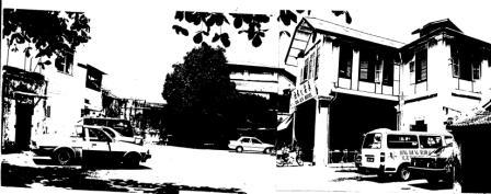
(Photo below shows an urban space in Penang: copyright Naziaty Mohd Yaacob)
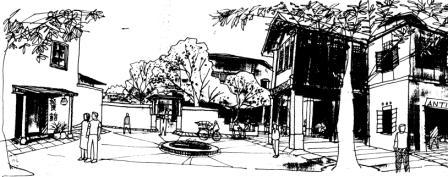
(Illustration above shows the urban design idea for the same space: copyright Naziaty Mohd Yaacob)
Main Link:
http://www.planning.org/25anniversary/influentials.htm
Hippodamus (5th century BC) of Miletus was a Greek architect who introduced order and regularity into the planning of cities, which were intricate and confusing. For Pericles, he planned the arrangement of the harbor-town Peiraeus at Athens. When the Athenians founded Thurii in Italy, he accompanied the colony as architect. Later, in 408 B.C., he superintended the building of the new city of Rhodes. His schemes consisted of series of broad, straight streets, intersecting one another at right angles.
Haussmann (1809-1891) was a French civic planner who is associated with the rebuilding of Paris. He was born in that city of a Protestant family of German descent. Commissioned by Napoleon III to instigate a program of planning reforms in Paris, Haussmann laid out the Bois de Boulogne, and made extensive improvements in the smaller parks. The gardens of the Luxembourg Palace were cut down to allow of the formation of new streets, and the Boulevard de Sebastopol, the southern half of which is now the Boulevard St. Michel, was built through a populous district. Additional, sweeping changes made wide “boulevards” of previously narrow streets. A new water supply, a gigantic system of sewers, new bridges, the opera and other public buildings, and the inclusion of outlying districts were among the new Haussmann’s achievements. His bold handling of the public funds called forth Jules Ferry’s indictment, in 1867.
Camillo Sitte (1843-1903) is best known among urban planners and architects for his book City Planning According to Its Artistic Principles from 1889. He strongly criticized the prevailing emphasis on broad, straight boulevards, public squares arranged primarily for the convenience of traffic, and efforts to strip major public or religious landmarks of adjoining smaller structures that were regarded as encumbering such monuments of the past.
Sitte proposed instead to follow what he believed to be the design objectives of those whose streets and buildings shaped medieval cities. He advocated curving or irregular street alignments to provide ever-changing vistas. He pointed out the advantages of what came to be know as “turbine squares” — civic spaces served by streets entering in such a way as to resemble a pinwheel in plan. His teachings became widely accepted in Austria, Germany, and Scandinavia. In less than a decade, his style of urban design came to be accepted as the norm in those countries.
Sitte’s link:
http://www.library.cornell.edu/Reps/DOCS/sitte.htm
Ebenezer Howard (1850-1928) came to America from England at the age of 21. He settled in Nebraska, and soon discovered that he was not meant to be a farmer. He moved to Chicago and worked as a reporter for the courts and newspapers. By 1876, he was back in England, where he found a job with a firm producing the official Parliamentary reports, and he spent the rest of his life in this occupation.
Howard read widely and thought deeply about social issues, and one result was his book To-Morrow: A Peaceful Path to Real Reform (1898), reprinted in 1902 as Garden Cities of To-Morrow. This book called for the creation of new suburban towns of limited size, planned in advance, and surrounded by a permanent belt of agricultural land. Many suburbs were modeled after Howard’s “Garden Cities.” He believed they were the perfect blend of city and nature.
His ideas attracted enough attention and financial backing to begin Letchworth, a garden city in suburban London. A second garden city, Welwyn, was started after World War I. Their success led the British government to develop New Towns after World War II. This movement produced more than 30 communities, most significantly perhaps Milton Keynes. Howard’s ideas inspired other planners such as Frederick Law Olmsted II and Clarence Perry.
Arguably the intellectual leader of the American city planning movement in the early twentieth century, Frederick Law Olmsted, Jr. (1870-1957) was a worthy son of a distinguished father. While still an adolescent, “Rick” Olmsted worked and studied under his father before entering Harvard. After graduation in 1894, he entered his father’s firm and a year later, as the elder Olmsted’s health deteriorated, he and his halfbrother took it over under the name Olmsted Brothers.
His active involvement in urban planning began in 1901 with his appointment as one of four members of the Senate Park Commission with Daniel Burnham, Charles McKim, and August St. Gaudens. He maintained a special interest in Washington, serving on the Fine Arts Commission from its founding in 1910 to 1918. During the First World War, he was manager for town planning in the U.S. Housing Corporation. This body planned and built near war industries a large number of housing projects, some of them approaching new towns in size. From 1926, when it was established, to 1932 he was a member of the National Capital Park and Planning Commission.
Olmsted was one of the moving figures in establishing the National Planning Conference and was its president from 1910 to 1919. When the professional members of this group and others formed the American City Planning Institute in 1917, they elected Olmsted the first president.
In the 1920s, he was also a member of the Advisory Committee on City Planning and Zoning, established by Commerce Secretary Herbert Hoover. Olmsted helped design the innovative Forest Hills Gardens project in Queens, as well as the industrial town of Torrance, California. He also prepared plans for existing cities: Detroit, Utica, Boulder, New Haven (with Cass Gilbert), and Pittsburgh (with Bion J. Arnold and John R. Freeman), Rochester (with Arnold W. Brunner and Bion J. Arnold); and Newport.
Father of the “Neighborhood Unit Concept,” Clarence Perry (1872-1944) codified Raymond Unwin’s designs of neighborhood. (Unwin thought of the street, the district, and the town as larger wholes.) While living in the garden suburb of Forest Hills Gardens, New York, he worked on his scheme for the “neighborhood unit” — a self-contained residential area that would be bounded by major streets, with shops at the intersections and a school in the middle. The concept for the self-contained neighborhood unit was made public with the publication of Housing for the Mechanic Age (1939). Perry also was the author of the “Regional Survey of New York and its Environs” (1929).
Le Corbusier (1887-1965) was without doubt the most influential, most admired, and most maligned architect of the twentieth century. Through his writing and his buildings, he is the main player in the Modernist story, his visions of homes and cities as innovative as they are influential. Many of his ideas on urban living became the blueprint for post-war reconstruction, and the many failures of his would-be imitators led to Le Corbusier being blamed for the problems of western cities in the 1960s and 1970s.
In the 1920s and 1930s, Le Corbusier’s most significant work was in urban planning. In such published plans as La Ville Contemporaine (1922), the Plan Voisin de Paris (1925), and the several Villes Radieuses (1930-36). He advanced ideas dramatically different from the comfortable, low-rise communities proposed by earlier garden city planners. During this 20-year span, he also built many villas and several small apartment complexes and office buildings.
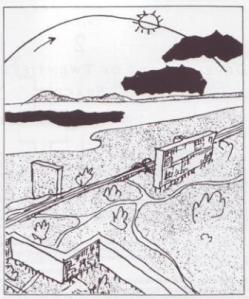
(Below is Le Corbusier’s diagram taken from Trancik)
Lewis Mumford‘s (1895-1988) long life was marked by work in urban planning, history, and political and social commentary. He viewed architectural congestion as a dehumanizing influence and was instrumental in founding the Regional Planning Association of America in 1923.
His series of writings tracing the history of cities over the last 1,000 years was very successful and included The Culture of Cities (1938), The Condition of Man (1944), and The Conduct of Life (1951).
Mumford continued his prodigious output well into his later years, producing The Pentagon of Power in 1971. Mumford received the National Medal of Arts in 1986.
Jane Jacobs (1916-2006) was born in Scranton, Pennsylvania. Her father was a physician and her mother taught school and worked as a nurse. After high school and a year spent as a reporter on the Scranton Tribune, Jacobs went to New York, where she found a succession of jobs as a stenographer and wrote freelance articles about the city’s many working districts, which fascinated her.
In 1952, after a number of writing and editing jobs ranging in subject matter from metallurgy to U.S. geography for foreign readers, she became an associate editor of Architectural Forum. She became increasingly skeptical of conventional planning beliefs as she noticed that the city rebuilding projects she wrote about did not seem safe, interesting, lively, or economically beneficial for cities once the projects were operational. She gave a speech to that effect at Harvard in 1956, and this led to an article in Fortune magazine entitled “Downtown Is for People.” This in turn led her to write The Death and Life of Great American Cities. The book was published in 1961 and permanently the debate about urban renewal and the future of cities.
Thirty years after its publication, the New York Times described The Death and Life of Great American Cities as “perhaps the most influential single work in the history of town planning. … [It] can also be seen in a much larger context. It is first of all a work of literature; the descriptions of street life as a kind of ballet and the bitingly satiric account of traditional planning theory can still be read for pleasure even by those who long ago absorbed and appropriated the book’s arguments.”
Kevin Lynch (1918-1984) was a significant contributor to twentieth-century city planning and city design. He was educated at Yale University, Rensselaer Polytechnic Institute, and most notably, Massachusetts Institute of Technology. He became a professor at MIT in 1963, and eventually earned professor emeritus status. Aside from research and teaching, Lynch was consultant to the state of Rhode Island, New England Medical Center, Boston Redevelopment Authority, Puerto Rico Industrial Development Corp., M.I.T. Planning Office, and other organizations.
Lynch produced seven books during his outstanding career. In his most famous work, Image of the City (1960), he described a five-year study that used Boston, Los Angeles, and Jersey City as case studies. His research revealed which elements in the built structure of a city are important in the popular perception of the city.
Ian McHarg (1920-2001) was one of the true pioneers of the environmental movement. Born near the gritty, industrial city of Glasgow, he gained an early appreciation of the need for cities to better accommodate the qualities of the natural environment that until then had largely been shunned. After serving in World War II, McHarg emigrated to the United States to attend Harvard University, where he earned degrees in landscape architecture and city planning. He was responsible for the creation of the Department of Landscape Architecture at the University of Pennsylvania.
However, McHarg would not be confined to the halls of academia. In 1960, he hosted “The House We Live In” on the CBS television network — an early effort to publicize discussion about humans and their environment. The show, along with a later PBS documentary, helped make McHarg a household name.
He published his landmark book, Design With Nature, in 1969. In it, McHarg spelled out the need for urban planners to consider an environmentally conscious approach to land use, and provided a new method for evaluating and implementing doing so. Today, Design With Nature is considered one of the landmark publications in the environmental movement, helping make McHarg arguably the most important landscape architect since Frederick Law Olmsted.
Notes: Gordon Cullen’s Concise Townscape Theory
Gordon Cullen (1914-1994) was an English architect,. an urban designer who carried on the of the Townscape movement theme. Later on he wrote and published the “Townscape” book in 1961. He was a key motivator and activist in the development of British theories of urban design in the post-war period. After his death, David Gosling & Norman Foster collected various examples of his work and put them together in the book ‘Visions of Urban Design’.
Gordon Cullen get famous by the Concise Townscape Theory. The “Townscape” book, one of Gordon Cullen’s masterpiece, illustrated with over 300 works selected from the drawings Gordon Cullen made during his lifetime, this anthology documents his influential career as an Urban Theorist, artist and illustrator from 1930 to 1990. The majority of his drawings have never been published before except in professional reports, and this book contains numerous drawings executed for the pleasure of observation as well as the product of his many consultancies.
Serial Vision Serial Vision is to walk from one end of the plan to another, at a uniform pace, will provide a sequence of revelations which are suggested in the serial drawings opposite, reading from left to right.
Place Place description is in a world of black and white the roads are for movement and the buildings for social and business purposes.
Content Content concerned with the intrinsic quality of the various subdivisions of the environment, and start with the great landscape categories of metropolis, town, arcadia, park, industrial, arable and wild nature.
Focal Point Focal point is the idea of the town as a place of assembly, of social intercourse, of meeting, was taken for granted throughout the whole of human civilization up to the twentieth century.
Closure Closure, may be differentiated from Enclosure, by contrasting ‘travel’ with ‘arrival’. Closure is the cutting up of the linear town system (streets, passages, etc.) into visually digestible and coherent amounts whilst retaining the sense of progression. Enclosure on the other hand provides a complete private world which is inward looking, static and self-sufficient.
Street Lighting Here we are concerned with the impact of a modern public lighting installation on towns and not, primarily, with the design of fittings. Naturally it is impossible to disassociate the two since, as in all townscape, we are concerned with two aspects: first, intrinsic design and second, the relationship or putting together of things designed.
Outdoor Publicity One contribution to modern townscape, startlingly conspicuous everywhere you look, but almost entirely ignored by the town planner, is street outdoor publicity. This is the most characteristic, and, potentially, the most valuable, contribution of the twentieth century to urban scenery. At night it has created a new landscape of a kind never before seen in history.
Here and There The practical result of so articulating the town into identifiable parts is that no sooner do we create a HERE than we have to admit a THERE, and it is precisely in the manipulation of these two spatial concepts that a large part of urban drama arises.
Man-made enclosure, if only of the simplest kind, divides the environment into HERE and THERE. On this side of the arch, in Ludlow, we are in the present, uncomplicated and direct world, our world. The other side is different, having in some small way a life of its own (a with-holding).
From the book “Concise Townscape”, (the architectural press, 1971)
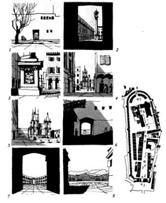 (Illustration above of Cullen’s Serial Vision theory taken from Trancik’s book)
urban-design-ppt1ablog


